On the foundation of our satellite remote sensing data, on our own, and in cooperation with international enterprises, Origin Space established a global network of remote sensing satellite centers. It provides customers with comprehensive, real-time remote sensing solutions.
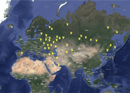
Global Remote Sensing Center Network in Partnership with Origin Space

Origin Space's own ground remote sensing centers
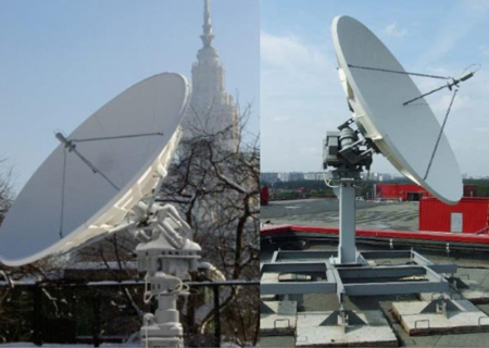
Overseas Ground Receiving Stations
Based on remote sensing and GIS, internet, cloud computing and other technologies, we can realize scientific management of the city, including accurate analysis, collaborative command and scientific governance of urban governance, and promote "scientific decision-making", "accurate governance", and "efficient service".
Urban Planning
Urban Environment
Urban Safety
Intelligent Management
The LEO satellite navigation augmentation system is a constellation system of multiple LEO satellites and ground systems. It can enhance the performance of the BeiDou satellite navigation system, effectively improve the stability and coverage of navigation signals, provide high-precision, fast convergence, low-cost, and reliable satellite positioning augmentation services for potential users globally, and realize real-time dynamic and quick navigation and positioning at the global centimeter (cm) level.
Public Location Services
Automated Driving
Geographic Information
Public Security
Precision Agriculture
Specialized Logistics Management
Mobile Communication
Power Networks
Aerospace
LEO-HTS network communication band using Ka, Ku, V, and others, with fast transmission speed, wide coverage, and communication band, regardless of terrain and geographical restrictions. Users only need to configure a portable antenna that can achieve network communication and significantly improve the situation that the local area can not receive an efficient navigation signal. Compared with other manufacturers who plan to launch thousands or tens of thousands of satellites, Origin Space can reduce the number of satellites to achieve the expected network effect, that is, channel rental costs are low, greatly reducing the costs.
Airborne Load
Marine Shipboard
Land Mobile Operations
Major Emergencies
Resource exploration
Military Communications
Autopilot
First Aid Communications
Communication Relay
Carry out targeted marine satellite services and build a set of marine intelligent service platform as the core of the platform consists of marine ecological environment monitoring, marine disaster monitoring, dynamic monitoring of marine natural resources, monitoring of key targets at sea, to create a safe, beautiful and productive ocean.
Marine Ecological Environment Monitoring
Wind Field Inversion
Ocean Wave Inversion
Sea surface Temperature
Marine Hazards
Dynamic Monitoring of Marine Natural Resources
Marine Key Target Monitoring
Marine Emergencies Monitoring
The development, utilization and protection of forest and grassland resources need to keep pace with economic development, so it is especially important to grasp the dynamic changes of resources and make timely decisions. Remote sensing can make repeated observations of regional forest and grassland in a short period of time and on a large scale, so that the dynamic changes of resources can be grasped in near real time and decisions can be made timely.
Forest Resource Management
Grassland Resource Management
Forest and Grassland Disaster Monitoring
Ecological Engineering Planning
Desertification Control
Carbon Asset Assessment
Combining wireless sensor network, drone remote sensing and satellite remote sensing technology to build an integrated agricultural information collection system in the sky and land, which can build a set of efficient closed loop in the links of ”land leveling - crop identification - seedling image analysis - growth analysis - accurate fertilization - yield estimation”, thus increasing yield and income generation.
Plot Management
Crop Identification
Early-warning Weather Monitoring
Pest Management
Intelligent Farm Machinery Deployment
Agricultural Insurance And Financial Services
Support real-time monitoring and inspection of power faults for transmission lines, including inspection task planning, inspection result analysis, image/image data management, inspection information query, inspection result display and other functions, incorporating aviation, image, communication technology and background analysis system to improve the safety, efficiency and intelligence of transmission line inspection.
Ground Settlement Analysis of Tower Slopes
Power Line Design
Identification of Features Along the Power Line
Power Line Vegetation Interference Analysis
Identification of Typical Geological Hazards of Power
Transmission Lines
UAV Power Patrol
Automatic Monitoring Service of Power Line Hill Fire
Forecasting and Warning of Meteorological Disasters
On Power Lines
New Energy Generation Planning
New Energy Generation Forecasting
Power Plant Planning And Management
Power Plant 3d Visualization
Focus on water resources monitoring, evaluation and management, water and drought disaster monitoring, water and soil conservation remote sensing monitoring and evaluation and other business directions. Form a comprehensive information service capability for water conservancy remote sensing application, for the Ministry of Water Resources, local water conservancy departments and other users continue to provide remote sensing monitoring products and services.
Accurate Identification of Water Shorelines
Chlorophyll A Concentration
Total Phosphorus
Total Nitrogen
Suspended Matter
Water Bloom
Black Smelly Water Body Monitoring
Water Pollution Traceability
Monitoring of Indiscriminate Occupation, Mining, Piling And Construction
Use "Satellite + UAV" throughout the patrol mission, scanning of targets in key areas, to provide timely and accurate real-time intelligence security in border areas for decision-making.
Island And Island Ecological Environment Monitoring
Illegal Sand Mining
Illegal Reclamation
Uses of the sea, Sea Inlet Random Discharge
Illegal Exploitation of Islands
Cross-border Fishing By Fishermen From Other Countries
Border Anomalies
Illegal Border Crossing
Illegal Surveillance
Illegal Geographic Information Mapping
Illegal Military Building Erection
Unmanned Aircraft Entry Shooting
Centering on the information service for fishery development, we build a wisdom and information system of “Two nuclei and one circle”. " Two nuclei" that is, respectively, with aquatic products and fishing vessels as the core, and "one circle" that is the wisdom fishery ecosystem, which organically integrates data of bathing ports, fishing vessels, crew members and aquatic products to realize business collaboration and wisdom service and promote the efficient and sustainable development of fishery industry.
Disaster Monitoring and Early Warning
Fishing Vessel Dynamics Monitoring
Fish Habitat Monitoring
Fishing Forecast
Remote sensing technology plays an important role in climate early warning, monitoring, disaster monitoring and related disaster prevention and mitigation efforts.
Temperature, pressure, humidity, wind, clouds, Thunderstorms
Typhoon
Rainstorm
Cold Wave
High Wind
Sandstorm
High Temperature
Drought
Frost
Haze
The integration of low-orbit remote sensing satellites and ground-based IoT is used to create an integrated "sky-air-ground" system to provide early warning services for natural disasters and urban emergency monitoring nationwide.
Earthquake
Heavy Winds
Thunderstorms
Storm Surges
Flood
Forest Fires
Drought
Lifeline Damage
Building Fires
Building Collapse
Urban Flooding
Mudslides
Landslide
Mine Accident Monitoring
Tailings Pond Accidents
Hazardous Chemical Accidents
Engineering Construction Accidents
Firework Explosion
Crowded Trampling
Explosions at Key Events
Realize safety warning, supervision and law enforcement to mine by comprehensive use of remote sensing, big data, cloud computing, artificial intelligence and other advanced technologies. On the basis of the integration of multi-source heterogeneous space-air-ground data, we construct the space-air-ground integration perception system, to create special remediation, safety monitoring on production, risk warning, emergency command and other applications.
Safety Monitoring on Production
Risk Warning
Tailings Pond Special Rectification
Accident Response
Supervision of Closed Ponds
Upstream and Downstream Protection Supervision
Damage Assessment
Incident Management
Command and Dispatch
Information Release
Voice of The Masses
Expert Knowledge Base
System Management
Other Supervision


